Picture 1 of 4


Gallery
Picture 1 of 4


Have one to sell?
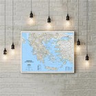
Greece Map National Geographic Classic Wall Laminated 77x60 cm (30.25x23.5in)

US $39.99
ApproximatelyAU $62.15
Condition:
Brand new
A new, unread, unused book in perfect condition with no missing or damaged pages. See the seller's listing for full details.
- Buy It NowGreece Map National Geographic Classic Wall Laminated 77x60 cm (30.25x23.5in)
Oops! Looks like we're having trouble connecting to our server.
Refresh your browser window to try again.
Postage:
US $36.00 (approx. AU $55.95) Economy Shipping from outside US.
International delivery of items may be subject to customs processing and additional charges.
Located in: Neo Psychiko, Greece
Delivery:
Estimated between Tue, 26 Aug and Tue, 23 Sep to 94104
Returns:
No returns accepted.
Payments:
Shop with confidence
Seller assumes all responsibility for this listing.
eBay item number:134439421806
Item specifics
- Condition
- Region
- World
- Features
- Laminated
- Country/Region of Manufacture
- United States
- ISBN
- 9780792236092
- EAN
- 9780792236092
About this product
Product Identifiers
Publisher
National Geographic Maps
ISBN-10
0792236092
ISBN-13
9780792236092
eBay Product ID (ePID)
204355633
Product Key Features
Number of Pages
1 Pages
Publication Name
Greece-National Geographic
Language
English
Publication Year
2022
Subject
Travel, Reference, Science, Earth Sciences / Geography, Europe / General, Atlases, Gazetteers & Maps (See Also Travel / Maps & Road Atlases)
Type
Map
Series
National Geographic Reference Map Ser.
Format
Sheet Map, Rolled
Dimensions
Item Weight
3 Oz
Item Length
23.5 in
Item Width
30.2 in
Additional Product Features
Edition Number
2022
Intended Audience
Trade
Illustrated
Yes
Synopsis
National Geographic's wall map of Greece and the Aegean is one of the largest and most detailed maps of the area. The signature Classic style design uses a bright, easy-to-read color palette and stunning shaded relief. Coverage includes mainland Greece along with areas of bordering Albania, Macedonia, Bulgaria and Turkey. Surrounding waterways, like the Aegean and Ionian Seas are shown with depth curves and soundings along with hundreds of islands, including Crete, Rhodes and Euboea. Also shown are thousands of place names, accurate boundaries, national parks, ruins and major infrastructure networks such as roads, highways, airports, railroads, canals and ferry routes. The map is encapsulated in heavy-duty 1.6 mil laminate which makes the paper much more durable and resistant to the swelling and shrinking caused by changes in humidity. Laminated maps can be framed without the need for glass, so the fames can be much lighter and less expensive. Map Scale = 1:1,494,000 Sheet Size = 30.25" x 23.5", National Geographic's wall map of Greece and the Aegean is one of the largest and most detailed maps of the area. The signature Classic style design uses a bright, easy-to-read color palette and stunning shaded relief. Coverage includes mainland Greece along with areas of bordering Albania, North Macedonia, Bulgaria and Turkey. Surrounding waterways, like the Aegean and Ionian Seas are shown with depth curves and soundings along with hundreds of islands, including Crete, Rhodes and Euboea. Also shown are thousands of place names, accurate boundaries, national parks, ruins and major infrastructure networks such as roads, highways, airports, railroads, canals and ferry routes. The map is encapsulated in heavy-duty 1.6 mil laminate which makes the paper much more durable and resistant to the swelling and shrinking caused by changes in humidity. Laminated maps can be framed without the need for glass, so the frames can be much lighter and less expensive. Map Scale = 1:1,494,000 Sheet Size = 30.25" x 23.5"
Item description from the seller
Seller feedback (57)
- 0***1 (17)- Feedback left by buyer.Past 6 monthsVerified purchaseRecieved with thanks, all went well.Aquatica 8" Removable Dome Shade for wide angle lenses fits all 8” dome ports (#134345908283)
- e***l (180)- Feedback left by buyer.More than a year agoVerified purchaseGreat communication and extremely fast shipping. Arrived in perfect condition just as described. Thank you!ASUS Optional Fans (SET OF 2) 13G070341001 Motherboard (YD124515MB) - 2 FAN SET (#134415230389)
- a***5 (0)- Feedback left by buyer.More than a year agoVerified purchaseL envoi de Sharkman77 et la réception ont été très positifs. L objet très bien emballé est arrivé en très bon état et dans des délais conformes à mon attente compte tenu de la distance de transport. C est parfait, merci!Huge Syrinx Aruanus Australian Trumpet Conch Seashell 17.6 in (446 mm) 5 lbs (#134459322541)
More to explore:
- National Geographic Maps & Atlases,
- National Geographic Folding Map Maps & Atlases,
- National Geographic Maps & Atlases in English,
- Greece Maps & Atlases,
- Laminated Maps & Atlases,
- Non-Fiction National Geographic Fiction & Books,
- Adventure Non-Fiction National Geographic Fiction & Books,
- National Geographic School Textbooks & Study Guides in English,
- Travel Non-Fiction Travel Guide National Geographic Illustrated Fiction & Books,
- Travel Non-Fiction Travel Guide National Geographic Paperback Fiction & Books
Seller feedback (57)
- 0***1 (17)- Feedback left by buyer.Past 6 monthsVerified purchaseRecieved with thanks, all went well.Aquatica 8" Removable Dome Shade for wide angle lenses fits all 8” dome ports (#134345908283)
- e***l (180)- Feedback left by buyer.More than a year agoVerified purchaseGreat communication and extremely fast shipping. Arrived in perfect condition just as described. Thank you!ASUS Optional Fans (SET OF 2) 13G070341001 Motherboard (YD124515MB) - 2 FAN SET (#134415230389)
- a***5 (0)- Feedback left by buyer.More than a year agoVerified purchaseL envoi de Sharkman77 et la réception ont été très positifs. L objet très bien emballé est arrivé en très bon état et dans des délais conformes à mon attente compte tenu de la distance de transport. C est parfait, merci!Huge Syrinx Aruanus Australian Trumpet Conch Seashell 17.6 in (446 mm) 5 lbs (#134459322541)