Picture 1 of 1
Gallery
Picture 1 of 1

Have one to sell?
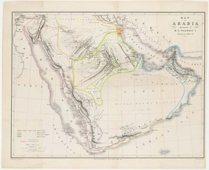
1865 Map Journey of W.G. Palgrave, Early European Map Interior of Arabia

US $425.00
ApproximatelyAU $651.44
or Best Offer
Condition:
“Soft folds with minor creasing and general wear. 51 x 42.5 cm (20.2 x 16.8 in)”
- Buy It Now1865 Map Journey of W.G. Palgrave, Early European Map Interior of Arabia
Oops! Looks like we're having trouble connecting to our server.
Refresh your browser window to try again.
Postage:
US $30.00 (approx. AU $45.98) FedEx Ground / FedEx Home Delivery®.
Located in: Belvedere Tiburon, California, United States
Delivery:
Estimated between Tue, 12 Aug and Mon, 18 Aug to 94104
Returns:
14-day returns. Buyer pays for return postage. If you use an eBay postage label, it will be deducted from your refund amount.
Payments:
Shop with confidence
Seller assumes all responsibility for this listing.
eBay item number:146715655588
Item specifics
- Seller notes
- “Soft folds with minor creasing and general wear. 51 x 42.5 cm (20.2 x 16.8 in)”
- Date Range
- 1800-1899
- Printing Technique
- Lithography
- Year
- 1865
- Original/Reproduction
- Antique Original
Item description from the seller

Seller feedback (34)
- a***i (13894)- Feedback left by buyer.Past monthVerified purchaseGreat seller, wonderful item and shipped quickly. Thanks!!
- 2***m (89)- Feedback left by buyer.Past yearVerified purchaseExcellent to work with. Item was exactly as described. Would definitely work with this seller again.[Sutro Baths] ON THE SHORE OF THE PACIFIC OCEAN (#145422041115)
- 2***8 (268)- Feedback left by buyer.More than a year agoVerified purchaseVery helpful seller. Item arrived very nicely packaged in acid-free sleeve and robust tube. Quite quick, bearing in mind trans-Atlantic journey. Seller very highly recommended.“SWORD AREA” BEACH CHARTLET. Enlargement of Portion F.1016 (#145422435385)
More to explore:
- Antique European Maps & Atlases Portugal,
- Antique European Maps & Atlases Greece,
- Antique European Maps & Atlases Sweden,
- Antique European Maps & Atlases England,
- Antique European Maps & Atlases Belgium,
- Antique European Maps & Atlases John Speed,
- Antique European Maps & Atlases 1800-1899 Date Range,
- Antique European Maps & Atlases 1910-1919 Date Range,
- Antique School Maps,
- Topographical Map Antique Australia/Oceania Atlas Maps
Seller feedback (34)
- a***i (13894)- Feedback left by buyer.Past monthVerified purchaseGreat seller, wonderful item and shipped quickly. Thanks!!
- 2***m (89)- Feedback left by buyer.Past yearVerified purchaseExcellent to work with. Item was exactly as described. Would definitely work with this seller again.[Sutro Baths] ON THE SHORE OF THE PACIFIC OCEAN (#145422041115)
- 2***8 (268)- Feedback left by buyer.More than a year agoVerified purchaseVery helpful seller. Item arrived very nicely packaged in acid-free sleeve and robust tube. Quite quick, bearing in mind trans-Atlantic journey. Seller very highly recommended.“SWORD AREA” BEACH CHARTLET. Enlargement of Portion F.1016 (#145422435385)