Picture 1 of 6


Gallery
Picture 1 of 6


Have one to sell?
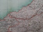
1898 Carmarthenshir

GBP 14.95
ApproximatelyAU $30.73
or Best Offer
Condition:
- Buy It Now1898 Carmarthenshire & North Pembrokeshire large map. 125 yrs old. Aberystwith.
Oops! Looks like we're having trouble connecting to our server.
Refresh your browser window to try again.
Postage:
GBP 8.99 (approx. AU $18.48) Royal Mail International Standard.
International delivery of items may be subject to customs processing and additional charges.
Located in: Swindon, United Kingdom
Delivery:
Estimated between Fri, 8 Aug and Thu, 21 Aug to 94104
Returns:
14-day returns. Buyer pays for return postage. If you use an eBay postage label, it will be deducted from your refund amount.
Payments:
Shop with confidence
Seller assumes all responsibility for this listing.
eBay item number:155700694918
Item specifics
- Antique
- Yes
- Date Range
- 1800-1899
- Type
- County Map
- Printing Technique
- Lithography
- Format
- Atlas Map
- Year
- 1898
- Era
- 1800s
- Cartographer/Publisher
- John Bartholomew
- Original/Reproduction
- Antique Original
- City
- Fishguard
- Country/Region
- Wales
- County
- Carmarthenshire, Cardiganshire, Pembrokeshire
Item description from the seller

Seller feedback (764)
- a***1 (280)- Feedback left by buyer.Past 6 monthsVerified purchaseItem received ok, and in that sense no issue. But on inspection, it is not what was illustrated in the listing, which was a slightly later edition (c1900?) edition of the same map. However, not to worry, I'm happy with it.
- o***r (1077)- Feedback left by buyer.Past monthVerified purchaseThe map was just what I was looking for. Arrived on time and in good shape. Dealer communication was great. A+
- j***4 (42)- Feedback left by buyer.Past 6 monthsVerified purchaseItem matched photos and description. This was my first time receiving an item from the UK; I found the shipping time to be quick considering the distance traveled. Print is quite lovely! Very pleased.Rare 1865 Wigandia Caracasana botanical print. 158 years old. (#155880244640)
More to explore:
- City Map Antique North America Atlas Maps,
- Antique North America County Maps,
- Topographical Map Antique North America Folding Maps,
- Topographical Map Antique North America Atlas Maps,
- North Dakota Antique North America Atlas Maps,
- Antique North America Geological Maps,
- Antique North American Maps & Atlases Iowa,
- Antique North American Maps & Atlases Illinois,
- Antique North American Maps & Atlases Kansas,
- County Map Antique North America Atlas
Seller feedback (764)
- a***1 (280)- Feedback left by buyer.Past 6 monthsVerified purchaseItem received ok, and in that sense no issue. But on inspection, it is not what was illustrated in the listing, which was a slightly later edition (c1900?) edition of the same map. However, not to worry, I'm happy with it.
- o***r (1077)- Feedback left by buyer.Past monthVerified purchaseThe map was just what I was looking for. Arrived on time and in good shape. Dealer communication was great. A+
- j***4 (42)- Feedback left by buyer.Past 6 monthsVerified purchaseItem matched photos and description. This was my first time receiving an item from the UK; I found the shipping time to be quick considering the distance traveled. Print is quite lovely! Very pleased.Rare 1865 Wigandia Caracasana botanical print. 158 years old. (#155880244640)