
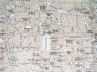
1925 ORIGINAL VINTAGE MAP OF COLOGNE KOLN KÖLN / GERMANY
US $25.99US $25.99
Fri, 04 Apr, 10:07Fri, 04 Apr, 10:07
Picture 1 of 9


Gallery
Picture 1 of 9


1925 ORIGINAL VINTAGE MAP OF COLOGNE KOLN KÖLN / GERMANY
US $25.99
ApproximatelyAU $39.81
or Best Offer
Condition:
“MAP SIZE: 10 3/4" x 9 1/4" (27 x 23 cm). THE MAP IS FOLDED SEVERAL TIMES, AS ORIGINALLY ISSUED.”
Oops! Looks like we're having trouble connecting to our server.
Refresh your browser window to try again.
Postage:
Free Standard Shipping from Canada.
International delivery of items may be subject to customs processing and additional charges.
Located in: Montreal, Quebec, Canada
Delivery:
Estimated between Mon, 7 Jul and Tue, 15 Jul to 91768
Returns:
60-day returns. Seller pays for return postage.
Payments:
Shop with confidence
Seller assumes all responsibility for this listing.
eBay item number:156793140274
Item specifics
- Seller notes
- “MAP SIZE: 10 3/4" x 9 1/4" (27 x 23 cm). THE MAP IS FOLDED SEVERAL TIMES, AS ORIGINALLY ISSUED.”
- Date Range
- 1920-1929
Item description from the seller
Seller Feedback
No Feedback yet
More to explore:
- Vintage Original Antique Folding Maps,
- Antique European Maps & Atlases Germany,
- Vintage Original Antique World Maps & Atlases,
- Vintage Original Antique Maps, Atlases & Globes,
- Vintage Original Antique North America Folding Maps,
- Vintage Original Antique Australia/Oceania Topographical Maps,
- California Vintage Original Antique North American Maps & Atlases,
- Vintage Reproduction Antique Wall Maps,
- Vintage Original 1960-1969 Date Range Antique Australia/Oceania Maps & Atlases,
- Antique Original Antique World Maps & Atlases