
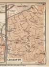
1910 ANTIQUE CITY MAP OF DERBY / LEICESTER / EAST MIDLANDS / ENGLAND
US $25.75US $25.75
Sun, 27 Apr, 04:34Sun, 27 Apr, 04:34
Picture 1 of 3


Gallery
Picture 1 of 3


Have one to sell?
1910 ANTIQUE CITY MAP OF DERBY / LEICESTER / EAST MIDLANDS / ENGLAND
US $25.75
ApproximatelyAU $39.56
or Best Offer
Condition:
“GOOD. SIZE: 6" x 4" (15 x 10 CM).”
Oops! Looks like we're having trouble connecting to our server.
Refresh your browser window to try again.
Postage:
Free Standard Shipping from Canada.
International delivery of items may be subject to customs processing and additional charges.
Located in: Montreal, Quebec, Canada
Delivery:
Estimated between Wed, 23 Jul and Mon, 28 Jul to 94104
Returns:
60-day returns. Seller pays for return postage.
Payments:
Shop with confidence
Seller assumes all responsibility for this listing.
eBay item number:156905357293
Item specifics
- Seller notes
- “GOOD. SIZE: 6" x 4" (15 x 10 CM).”
- Date Range
- 1910-1919
- Type
- City Map
- Year
- 1910
- City
- DERBY LEICESTER
- Country/Region
- England
Item description from the seller
Seller Feedback
No Feedback yet
More to explore:
- Antique City Maps,
- Antique European Maps & Atlases England,
- Antique Original Antique City Maps,
- Antique World City Maps,
- Antique Europe City Maps,
- City Map Antique North America Atlas Maps,
- Antique School Maps,
- United States of America Antique North America City Maps,
- Antique Wall Maps,
- Australia Antique Maps & Atlases