Picture 1 of 1
Stock photo

Picture 1 of 1
Stock photo
Catskill Park by National Geographic Maps - Trails Illustrated and National Geographic Maps Staff (2023, Sheet Map, Folded)

ZUBER (268161)
97.9% positive feedback
Price:
US $33.54
ApproximatelyAU $51.82
+ $14.85 postage
Returns:
30-day returns. Buyer pays for return postage. If you use an eBay postage label, it will be deducted from your refund amount.
Condition:
CATSKILL PARK (NATIONAL GEOGRAPHIC TRAILS ILLUSTRATED MAP) By National Geographic Maps - Trails Illustrated **BRAND NEW**.
- Buy It NowCATSKILL PARK (NATIONAL GEOGRAPHIC TRAILS ILLUSTRATED MAP) **BRAND NEW**
Oops! Looks like we're having trouble connecting to our server.
Refresh your browser window to try again.
About this product
Product Identifiers
PublisherNational Geographic Maps
ISBN-101566955882
ISBN-139781566955881
eBay Product ID (ePID)113450648
Product Key Features
Edition2023
Book TitleCatskill Park
Number of Pages2 Pages
LanguageEnglish
TopicMaps & Road Atlases (See Also Reference / Atlases, Gazetteers & Maps), Special Interest / Hikes & Walks, United States / Northeast / Middle Atlantic (NJ, NY, Pa)
Publication Year2023
IllustratorYes
GenreTravel
AuthorNational Geographic Maps-Trails Illustrated, National Geographic Maps Staff
Book SeriesNational Geographic Trails Illustrated Map Ser.
FormatSheet Map, Folded
Dimensions
Item Height0.3 in
Item Weight3 Oz
Item Length9.2 in
Item Width4.2 in
Additional Product Features
Intended AudienceTrade
Series Volume Number755
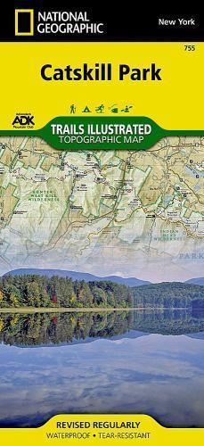
Synopsis- Waterproof - Tear-Resistant - Topographic Map National Geographic's Trails Illustrated map of Catskill Park is designed to meet the needs of outdoor enthusiasts by combining valuable information with unmatched detail of a park that consists of 700,000 acres of beautiful forests, mountains, rivers, and lakes. Created in partnership with the Adirondack Mountain Club (ADK) that provided trail information from its Forest Preserve Series of trail guides, this map will prove invaluable regardless of the season or the reason for your visit. Key areas of interest featured on this map include Ashokan, Pepacton, and Schoharie reservoirs; Belle Ayr Mountain; Slide Mountain Wilderness; Campbell Mountain; and Mongaup Pond. The print version of the map includes an inset of North/South Lake for additional detail. Whatever your chosen activity, the Catskill Park map can guide you off the beaten path and back again with a handy trail chart showing location, mileage, trail use, and difficulty levels for dozens of trails. Mileages between intersections are shown and the map base includes contour lines and elevations for summits, passes and many lakes. The Shawangunk Mountain Scenic Byway is noted for those wishing to take in the scenery by car. Public fishing easements, footbridges, swimming areas, snowmobile parking areas, boat launches, covered bridges, waterfalls, ski areas, and other points of interest are clearly marked. Every Trails Illustrated map is printed on "Backcountry Tough" waterproof, tear-resistant paper. A full UTM grid is printed on the map to aid with GPS navigation. Other features found on this map include: Ashokan Reservoir, Black Dome, Blackhead, Catskill Mountains, Cornell Mountain, Doubletop Mountain, Graham Mountain, Hunter Mountain, Kingston, Peekamoose Mountain, Pepacton Reservoir, Plateau Mountain, Rondout Reservoir, Slide Mountain, Table Mountain, Thomas Cole Mountain, Vly Mountain, Wawarsing, West Kill Mountain. Map Scale = 1:75,000 Sheet Size = 25.5" x 37.75" Folded Size = 4.25" x 9.25", * Waterproof * Tear-Resistant * Topographic Map National Geographic's Trails Illustrated map of Catskill Park is designed to meet the needs of outdoor enthusiasts by combining valuable information with unmatched detail of a park that consists of 700,000 acres of beautiful forests, mountains, rivers, and lakes. Created in partnership with the Adirondack Mountain Club (ADK) that provided trail information from its Forest Preserve Series of trail guides, this map will prove invaluable regardless of the season or the reason for your visit. Key areas of interest featured on this map include Ashokan, Pepacton, and Schoharie reservoirs; Belle Ayr Mountain; Slide Mountain Wilderness; Campbell Mountain; and Mongaup Pond. The print version of the map includes an inset of North/South Lake for additional detail. Whatever your chosen activity, the Catskill Park map can guide you off the beaten path and back again with a handy trail chart showing location, mileage, trail use, and difficulty levels for dozens of trails. Mileages between intersections are shown and the map base includes contour lines and elevations for summits, passes and many lakes. The Shawangunk Mountain Scenic Byway is noted for those wishing to take in the scenery by car. Public fishing easements, footbridges, swimming areas, snowmobile parking areas, boat launches, covered bridges, waterfalls, ski areas, and other points of interest are clearly marked. Every Trails Illustrated map is printed on "Backcountry Tough" waterproof, tear-resistant paper. A full UTM grid is printed on the map to aid with GPS navigation. Other features found on this map include: Ashokan Reservoir, Black Dome, Blackhead, Catskill Mountains, Cornell Mountain, Doubletop Mountain, Graham Mountain, Hunter Mountain, Kingston, Peekamoose Mountain, Pepacton Reservoir, Plateau Mountain, Rondout Reservoir, Slide Mountain, Table Mountain, Thomas Cole Mountain, Vly Mountain, Wawarsing, West Kill Mountain. Map Scale = 1:75,000 Sheet Size = 25.5" x 37.75" Folded Size = 4.25" x 9.25"
Ratings and reviews
Most relevant reviews
- 01 Nov, 2017
Never Get Lost
Always have a map and compass when hiking it may save your life.map waterproof and tear resistant.
Verified purchase: YesCondition: New
- 23 Jun, 2020
Excellent map
Excellent map. Clear, descriptive and durable. Worth the purchase for orienting.Verified purchase: YesCondition: New
- 26 Sep, 2018
useful
helps me choose where to go today,Verified purchase: YesCondition: New
- 01 Apr, 2020
Map
Highly detailed and accurate mapVerified purchase: YesCondition: New


![NKJV Gift and Award Bible Red Letter Edition [White] by Thomas Nelson (2018, Trade Paperback)](https://i.ebayimg.com/thumbs/images/g/mT0AAOSwDmBY5NqN/s-l225.jpg)


![NKJV Gift And Award Bible Red Letter Edition [White]: Holy Bible, New King James](https://i.ebayimg.com/images/g/bZsAAOSwJ~NoIuAK/s-l225.jpg)