
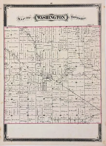
1884 WASHINGTON OHIO Plat Map - GEORGETOWN - DEFIANCE County (17x12)
US $24.00US $24.00
Thu, 03 Jul, 08:02Thu, 03 Jul, 08:02
Picture 1 of 2

Gallery
Picture 1 of 2


Have one to sell?
1884 WASHINGTON OHIO Plat Map - GEORGETOWN - DEFIANCE County (17x12)
Condition:
“GOOD CONDITION, DISCOLORATION, TEXT ON REVERSE SIDE”
Ended: 03 Jul, 2025 08:02:27 AEST
Oops! Looks like we're having trouble connecting to our server.
Refresh your browser window to try again.
Postage:
Free USPS Ground Advantage®.
Located in: Carefree, Arizona, United States
Delivery:
Estimated between Wed, 13 Aug and Tue, 19 Aug to 94104
Returns:
30-day returns. Seller pays for return postage.
Payments:
Shop with confidence
Seller assumes all responsibility for this listing.
eBay item number:226837675091
Item specifics
- Seller notes
- “GOOD CONDITION, DISCOLORATION, TEXT ON REVERSE SIDE”
- Date Range
- 1800-1899
- Type
- Plat map
- US State
- Ohio
- Format
- Atlas Map
- Printing Technique
- Lithography
- Year
- 1884
- Original/Reproduction
- Antique Original
- Cartographer/Publisher
- H.H. HARDESTY
- City
- Washington
- Country/Region
- United States of America
Item description from the seller
Seller Feedback
No Feedback yet