Picture 1 of 5


Gallery
Picture 1 of 5


Have one to sell?
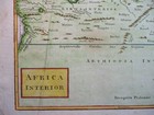
Antique Map of Ethiopia and Eygpt by Christoph Cellarius 1789

GBP 40.00
ApproximatelyAU $82.43
Condition:
- Buy It NowAntique Map of Ethiopia and Eygpt by Christoph Cellarius 1789
Oops! Looks like we're having trouble connecting to our server.
Refresh your browser window to try again.
Postage:
GBP 5.00 (approx. AU $10.30) Royal Mail International Signed.
International delivery of items may be subject to customs processing and additional charges.
Located in: Bath, United Kingdom
Delivery:
Estimated between Mon, 11 Aug and Tue, 19 Aug to 94104
Returns:
No returns accepted.
Payments:
Shop with confidence
Seller assumes all responsibility for this listing.
eBay item number:254383880712
Item specifics
- Cartographer/Publisher
- Cellarius
- Printing Technique
- Copper Plate
- Original/Reproduction
- Antique Original
- Type
- Topographical Map
- Year
- 1789
- Date Range
- 1700-1799
- Country/Region
- Eygpt, North Africa, Africa, Ethiopia
- Era
- 1700s
Item description from the seller

Seller feedback (486)
- s***b (102)- Feedback left by buyer.Past monthVerified purchaseThis fine example of Cary's ability as an engraver was delivered within three days of being ordered was exactly as described and arrived well-protected in a robust cardboard tube - not even a postage charge! Thankyou, Michael, for running your business at such a high standard of service.
- n***e (1751)- Feedback left by buyer.Past monthVerified purchaseTerrific seller! Lovely print, well packaged and quickly shipped. Thank you!!
- 0***1 (1588)- Feedback left by buyer.Past 6 monthsVerified purchaseReceived OK, great map, well packaged, easy transaction, A1.