Picture 1 of 4


Gallery
Picture 1 of 4


Have one to sell?
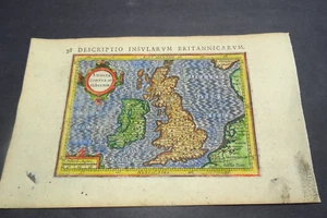
Antique Map of Great Britain and Ireland by Petrus Bertius 1618

GBP 85.00
ApproximatelyAU $173.96
Condition:
- Buy It NowAntique Map of Great Britain and Ireland by Petrus Bertius 1618
Oops! Looks like we're having trouble connecting to our server.
Refresh your browser window to try again.
Postage:
GBP 10.00 (approx. AU $20.47) Royal Mail International Signed.
International delivery of items may be subject to customs processing and additional charges.
Located in: Bath, United Kingdom
Delivery:
Estimated between Thu, 31 Jul and Fri, 8 Aug to 94104
Returns:
No returns accepted.
Payments:
Shop with confidence
Seller assumes all responsibility for this listing.
eBay item number:256487128415
Item specifics
- Date Range
- 1600-1699
- Type
- Topographical Map
- Printing Technique
- Copper Plate
- Year
- 1618
- Era
- 1600s
- Cartographer/Publisher
- Petrus Bertius
- Original/Reproduction
- Antique Original
- Country/Region
- England, Ireland, Scotland, Wales
Item description from the seller

Seller feedback (483)
- *****- Feedback left by buyer.Past 6 monthsVerified purchaseGreat thank you. Fast shipping, well packaged, item arrived in expected condition as described. x
- 0***1 (1574)- Feedback left by buyer.Past 6 monthsVerified purchaseReceived OK, great map, well packaged, easy transaction, A1.
- o***y (58)- Feedback left by buyer.Past monthVerified purchaseWell packaged and quick dispatch.