Picture 1 of 4


Gallery
Picture 1 of 4


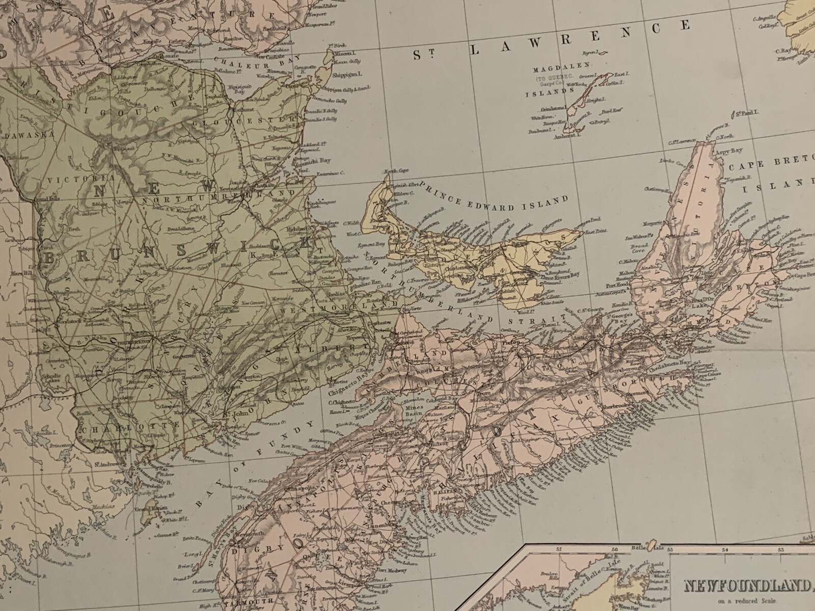

1883 EASTERN CANADA NEWFOUNDLAND LARGE MAP BY GEORGE PHILIP 69 cm x 54 cm

GBP 19.99
ApproximatelyAU $41.82
or Best Offer
Condition:
“The map is in good condition for its age.”
- Buy It Now1883 EASTERN CANADA NEWFOUNDLAND LARGE MAP BY GEORGE PHILIP 69 cm x 54 cm
Oops! Looks like we're having trouble connecting to our server.
Refresh your browser window to try again.
Postage:
GBP 12.00 (approx. AU $25.10) Parcelforce Global Express.
International delivery of items may be subject to customs processing and additional charges.
Located in: Manchester, United Kingdom
Delivery:
Estimated between Tue, 24 Jun and Fri, 27 Jun
Returns:
60-day returns. Seller pays for return postage.
Payments:
Shop with confidence
Seller assumes all responsibility for this listing.
eBay item number:256951799098
Item specifics
- Seller notes
- “The map is in good condition for its age.”
- Cartographer/Publisher
- John Bartholomew / George Philip
- Date Range
- 1800-1899
- Original/Reproduction
- Antique Original
- Country/Region
- Canada
- Canadian Province
- New Brunswick, Newfoundland & Labrador, Nova Scotia, Prince Edward Island, Quebec
- Era
- 1800s
- Format
- Atlas Map
- Type
- Political Map
- Year
- 1883
Item description from the seller

Seller feedback (5,106)
- 3***3 (281)- Feedback left by buyer.Past monthVerified purchaseMy antique print arrived speedily and safely, in perfect order. Well packaged. Just as seen on the scanner, looking good ! Very helpful communication, good value and I'm happy all round with the service from this seller. Reccomended. Thank you very much.
- a***e (3)- Feedback left by buyer.Past 6 monthsVerified purchaseI have already done this once, as soon as l received the item !! You should have it, but l will do it again. The postage was a very reasonable price. The item was well packaged. Safely and securely done. The item was exactly as described. I think good value. I look forward to doing business with this seller again. I am very happy with my purchase. Thank you very much.
- a***n (40)- Feedback left by buyer.Past 6 monthsVerified purchaseSafe packaging, item exactly as described, great value of this beautiful map, the communication with the seller was great and we solved a minor problem of the shipping which was a post office s fault1876 Turkish Empire, Caucasus, Georgia, Armenia Large Hand Coloured Map (#256654412422)
More to explore:
- Antique North American Maps & Atlases Canada,
- 30 to 49cm cm Diameter Antique World Globes & Celestial Globes,
- 30 to 49cm cm Diameter Antique World Worlds Globes,
- 20 to 29cm cm Diameter Antique World Worlds Globes,
- 5 to 19cm cm Diameter Antique World Worlds Globes,
- Antique School Maps,
- Australia Antique Maps & Atlases,
- Antique Folding Maps,
- Antique Geological Maps,
- Antique World Wall Maps
Seller feedback (5,106)
- 3***3 (281)- Feedback left by buyer.Past monthVerified purchaseMy antique print arrived speedily and safely, in perfect order. Well packaged. Just as seen on the scanner, looking good ! Very helpful communication, good value and I'm happy all round with the service from this seller. Reccomended. Thank you very much.
- a***e (3)- Feedback left by buyer.Past 6 monthsVerified purchaseI have already done this once, as soon as l received the item !! You should have it, but l will do it again. The postage was a very reasonable price. The item was well packaged. Safely and securely done. The item was exactly as described. I think good value. I look forward to doing business with this seller again. I am very happy with my purchase. Thank you very much.
- a***n (40)- Feedback left by buyer.Past 6 monthsVerified purchaseSafe packaging, item exactly as described, great value of this beautiful map, the communication with the seller was great and we solved a minor problem of the shipping which was a post office s fault1876 Turkish Empire, Caucasus, Georgia, Armenia Large Hand Coloured Map (#256654412422)