
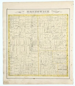
1874 OHIO Plat Map BRUNSWICK Township ORIGINAL (14x13) MEDINA COUNTY
US $30.00US $30.00
Wed, 09 Jul, 09:55Wed, 09 Jul, 09:55
Picture 1 of 5


Gallery
Picture 1 of 5


Have one to sell?
1874 OHIO Plat Map BRUNSWICK Township ORIGINAL (14x13) MEDINA COUNTY
US $30.00
ApproximatelyAU $46.34
or Best Offer
Condition:
“FAIR CONDITION, STAINING AND DISCOLORATION, BINDING HOLES OUTSIDE BORDER AT SIDE, PRINTED VIEWS ON ”... Read moreabout condition
Oops! Looks like we're having trouble connecting to our server.
Refresh your browser window to try again.
Postage:
Free USPS Ground Advantage®.
Located in: Carefree, Arizona, United States
Delivery:
Estimated between Thu, 7 Aug and Wed, 13 Aug to 94104
Returns:
30-day returns. Seller pays for return postage.
Payments:
Shop with confidence
Seller assumes all responsibility for this listing.
eBay item number:326661509153
Item specifics
- Seller notes
- Date Range
- 1800-1899
- Type
- Plat map
- US State
- Ohio
- Format
- Atlas Map
- Printing Technique
- Lithography
- Year
- 1874
- Original/Reproduction
- Antique Original
- Cartographer/Publisher
- L.H. EVERTS, CHICAGO ILLINOIS
- City
- BRUNSWICK
- Country/Region
- United States of America
Item description from the seller
Seller Feedback
No Feedback yet
More to explore:
- Antique Original Antique County Maps,
- Antique County Maps,
- Antique Original Antique North America County Maps,
- County Map Antique Europe Sheet Maps,
- Antique Europe County Maps,
- Antique North America County Maps,
- Illinois Antique North America County Maps,
- 1800-1899 Date Range Antique County Maps,
- United States of America 1800-1899 Date Range Antique North America County Maps,
- Antique Original Antique Australia/Oceania Folding Maps