Picture 1 of 3


Picture 1 of 3


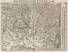
Map "Germaniae Tabula" (Germany) Sebastian Munster, 1572

GBP 300.00
ApproximatelyAU $584.65
or Best Offer
Condition:
Postage:
GBP 18.00 (approx. AU $35.08) Royal Mail International Tracked.
International delivery of items may be subject to customs processing and additional charges.
Located in: London, United Kingdom
Delivery:
Estimated between Fri, 27 Sep and Wed, 2 Oct to 43230
Please allow additional time if international delivery is subject to customs processing.
Returns:
No returns accepted.
Payments:
Shop with confidence
Seller assumes all responsibility for this listing.
eBay item number:335291097135
Item specifics
- Antique
- Yes
- Date Range
- 1500-1599
- Type
- Physical Map
- Format
- Sheet Map
- Printing Technique
- Woodcut
- Year
- 1572
- Era
- 1500s
- Cartographer/Publisher
- Sebastian Munster - Henric Petrina
- Original/Reproduction
- Antique Original
- Country/Region
- Germany
Item description from the seller

Popular categories from this Store
Seller Feedback (223)
- 0***0 (978)- Feedback left by buyer.Past monthVerified purchaseOUTSTANDING SELLER!!! Prompt delivery, Excellent packaging, Item as described, VERY PLEASED! FIVE STARS*****!
- 1***u (113)- Feedback left by buyer.Past 6 monthsVerified purchaseSuper item. Arrived promptly, carefully packaged, as described. Many thanks indeed. Highly recommended seller.
- s***o (499)- Feedback left by buyer.Past yearVerified purchaseThis is eBay at its very best! Responsive seller, amazingly fast international shipping, and absolutely beautiful item received very well-wrapped in perfect condition! A++++++Antique Caricature Map "England" Lilian Lancaster Tennant, 1912 (#335012016435)
More to explore:
- Antique European Maps & Atlases Germany,
- Antique European Maps & Atlases Germany 1800-1899 Date Range,
- Antique School Maps,
- Antique Nautical Maps,
- Australia Antique Maps & Atlases,
- Antique Geological Maps,
- Antique Wall Maps,
- Antique World Maps & Atlases,
- Antique World Wall Maps,
- Antique Celestial Maps & Atlases