
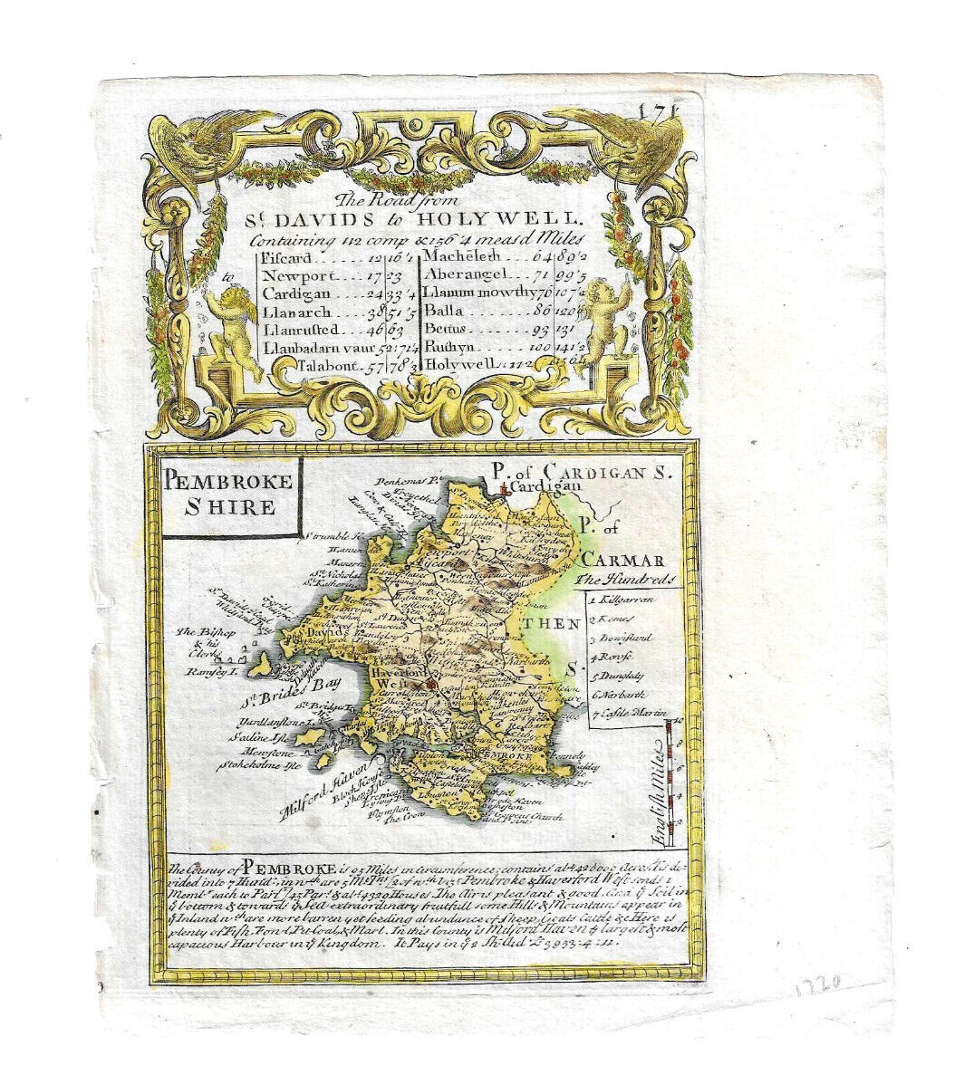
c.1720 MAP OF PEMBROKESHIRE WALES HAND-COLOURED FROM BOWLES BRITANNIA DEPICTA?
GBP 43.90GBP 43.90
Mon, 14 Jul, 03:28Mon, 14 Jul, 03:28
Picture 1 of 2


Gallery
Picture 1 of 2

Have one to sell?
c.1720 MAP OF PEMBROKESHIRE WALES HAND-COLOURED FROM BOWLES BRITANNIA DEPICTA?
Condition:
“Please look at scans and e-mail if more information is required. Uneven edge on left where removed ”... Read moreabout condition
Ended: 14 Jul, 2025 03:28:35 AEST
Oops! Looks like we're having trouble connecting to our server.
Refresh your browser window to try again.
Postage:
GBP 18.94 (approx. AU $38.91) International Priority Shipping to United States via eBay's Global Shipping Program.
Located in: London, United Kingdom
Import charges:
Free amount confirmed at checkout
Delivery:
Estimated between Fri, 22 Aug and Mon, 1 Sep to 94104
Includes international tracking
Returns:
No returns accepted.
Payments:
Shop with confidence
Seller assumes all responsibility for this listing.
eBay item number:336052817814
Item specifics
- Seller notes
- Antique
- Yes
- Date Range
- c.1720
- Type
- County Map
- Format
- Sheet Map
- Year
- 1720
- Original/Reproduction
- Antique Original
- Cartographer/Publisher
- ?John Bowen Emmanuel Owen
- Country/Region
- Wales
- County
- Pembrokeshire, Surrey
Item description from the seller
Seller feedback (1,270)
- *****- Feedback left by buyer.Past 6 monthsVerified purchaseBest thing I’ve bought this year , certainly lived up to the description was well wrapped for something so delicate arriving on time at reasonable cost thanks again A* eBayer
- *****- Feedback left by buyer.Past 6 monthsVerified purchaseSuch a lovely thing, I’m so happy to have it! This was wrapped very well, shipped quickly, and arrived to me in the US in perfect shape. Exactly as described, only even more lovely in person. Excellent experience, wonderful seller!
- *****- Feedback left by buyer.Past 6 monthsVerified purchaseGreat seller! The book arrived just as described and was well packaged. Thank you
This is a private listing and your identity will not be disclosed to anyone except the seller.
More to explore:
- Antique European Maps & Atlases Wales,
- New South Wales Antique Australia/Oceania Maps & Atlases,
- Antique European Maps & Atlases Wales 1800-1899 Date Range,
- New South Wales Australia Antique Australia/Oceania Maps & Atlases,
- Antique School Maps,
- Antique Silver Bowls,
- Brass Antique Asian Bowls,
- Antique Asian Bowls,
- Antique Maps, Atlases & Globes,
- Cloisonne Antique Asian Bowls