
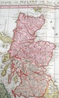
1729 HOMANN MAP of the BRITISH ISLES "MAGNA BRITANNIA", ORIGINAL COLOR
US $275.00US $275.00
Thu, 03 Jul, 02:01Thu, 03 Jul, 02:01
Picture 1 of 6


Gallery
Picture 1 of 6


Have one to sell?
1729 HOMANN MAP of the BRITISH ISLES "MAGNA BRITANNIA", ORIGINAL COLOR

US $275.00
ApproximatelyAU $427.42
Best Offer accepted
or Best Offer
Condition:
Oops! Looks like we're having trouble connecting to our server.
Refresh your browser window to try again.
Postage:
US $12.75 (approx. AU $19.82) Standard Shipping.
Located in: Akron, Ohio, United States
Delivery:
Estimated between Mon, 4 Aug and Sat, 9 Aug to 94104
Returns:
30-day returns. Buyer pays for return postage. If you use an eBay postage label, it will be deducted from your refund amount.
Payments:
Shop with confidence
Seller assumes all responsibility for this listing.
eBay item number:353067168889
Item specifics
- Cartographer/Publisher
- Johann Baptist Homann
- Printing Technique
- Engraved
- Original/Reproduction
- Antique Original
- Color
- Original hand color
- Format
- Atlas Map
- Features
- Antique
- Type
- Atlas Map
- Year
- 1729
- Date Range
- 1700-1799
- Country/Region
- Great Britain, Scotland, Ireland
Item description from the seller

Seller feedback (4,108)
- i***t (602)- Feedback left by buyer.Past 6 monthsVerified purchaseHow wonderful to see more pages of this prayer book being offered! Years ago I had bought two pages of this book… it is phenomenal to add to this mini collection. This vendor is thorough and highly informative about his offerings. He is trusted and highly recommended. He always ships quickly and with thoughtful packaging. A keen eye for valuable and historical items; these illuminated manuscript pages are as described, if not better.
- h***7 (1319)- Feedback left by buyer.Past 6 monthsVerified purchaseWonderful seller! Item is beautiful and as described! Prompt shipping, professionally packaged with wonderful paperwork on the item! Great communication! Thank you! ⭐️⭐️⭐️⭐️⭐️c. 1500 MEDIEVAL BOOK OF HOURS LEAF, FRANCE, CANDLEMAS - ILLUMINATED MINIATURE (#375836103183)
- j***r (219)- Feedback left by buyer.Past yearVerified purchaseNice map. Exactly as listed. Well packed a. Very fast shipping. Great seller.1894 MASSACHUSETTS, BOSTON, RAND MCNALLY, VERY LARGE ANTIQUE DETAILED MAP (#353672353798)
More to explore:
- Antique Original Antique County Maps,
- Antique Original Antique City Maps,
- Antique Original Antique Atlas Maps,
- Vintage Original Antique Folding Maps,
- Antique Original Antique Sheet Maps,
- Vintage Original Antique World Maps & Atlases,
- Antique Original Antique Europe Maps & Atlases,
- Antique Original Antique Maps, Atlases & Globes,
- Antique Original Antique North America Maps & Atlases,
- Vintage Original Antique Australia/Oceania Geological Maps
Seller feedback (4,108)
- i***t (602)- Feedback left by buyer.Past 6 monthsVerified purchaseHow wonderful to see more pages of this prayer book being offered! Years ago I had bought two pages of this book… it is phenomenal to add to this mini collection. This vendor is thorough and highly informative about his offerings. He is trusted and highly recommended. He always ships quickly and with thoughtful packaging. A keen eye for valuable and historical items; these illuminated manuscript pages are as described, if not better.
- h***7 (1319)- Feedback left by buyer.Past 6 monthsVerified purchaseWonderful seller! Item is beautiful and as described! Prompt shipping, professionally packaged with wonderful paperwork on the item! Great communication! Thank you! ⭐️⭐️⭐️⭐️⭐️c. 1500 MEDIEVAL BOOK OF HOURS LEAF, FRANCE, CANDLEMAS - ILLUMINATED MINIATURE (#375836103183)
- j***r (219)- Feedback left by buyer.Past yearVerified purchaseNice map. Exactly as listed. Well packed a. Very fast shipping. Great seller.1894 MASSACHUSETTS, BOSTON, RAND MCNALLY, VERY LARGE ANTIQUE DETAILED MAP (#353672353798)